12/13/07

Update on Westmoreland House Photo


House built in 1826.

It has been brought to my attention that this house that Fred Yenerall took 1971 is now up for sale. It's nice to know that it's still standing. The realtor's website also gave some fantastic information on this house.

Historic Facts about the house From the website of the Realtor:

  • The area known as Youngstown was settled in the late 1700s and early 1800s. Believed to be on a road cut through the area during the war between England and France in 1755-60, a number of taverns and inns operated in the area at the turn of the century.
  • The area became even more popular with travelers when the Greensburg Turnpike, part of the road running between Harrisburg and Pittsburgh, was authorized in 1815.
  • It wasn’t until the construction of Rt. 30 north of Youngstown that it became a quite residential community.
  • As would be expected from an area settled this early, many local homes, churches, schools, and businesses have a rich and long history.
  • But perhaps no individual’s history is as well known in the area as Arnold Palmer, who was born in 1929 in Latrobe and frequented the Latrobe Country Club with regularity as early as age 5.
  • Arnold and his brother, Gerry, not only both still own homes in Latrobe, they are your neighbors.
  • The home for sale, 207 Arnold Palmer, was built in 1826 and was the home of Jacob Brindle.
  • Jacob’s grandfather, Lawrence Brindle, came to Youngstown in the early 1800s and purchased a large tract of land, where he operated a farm with his two sons, John (Jacob’s father) and George.
  • George moved to Ohio while John, and later Jacob, inherited the farm.
  • Jacob and wife Peggy Aukerman and they had three decendents.
  • One son, E. Lewis Brindle, moved to Latrobe in his twenties and engaged in the grocery business.
  • Another son, John, continued to operate the farm with his wife and seven decendents
    One of them, Jacob, ran the farm and worked the coal deposits on the property for 25 years until he moved his farm to Latrobe.
  • This home has a rich history as both the site of an inn and a stagecoach shop.
  • Even more intriguing, a hidden compartment in the attic and local lore lead the current owners to believe it was once a stop on the Underground Railroad.

I love getting updated on these photos, and knowing that these places are still standing, and Tina, who brought this house to my attention, (she is the one that own's the round-house in a previous entry) also found updated photos of this house and forwarded them to me. It appears that the house still looks the same now as it did back then, or at least the front of the house does.

If you would like to be the new owner of this historic house, or see the virtual inside tour of the house and property you can Contact or visit the website of Tidwell Realty .

Mood's Covered Bridge Reopens soon


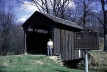
Mood's Covered Bridge Taken in 1965 by Fred Yenerall

Mood's Covered bridge will re-open soon and they will allow traffic to drive across the covered bridge.

Right now the Bridge is owned by PennDOT, after the dedication it will be given to the township at that time. It is still being worked on at the moment.

Mood's Covered bridge was destroyed by Arson in June of 2004.

12/5/07

Order your prints now for Christmas and Save Money

As you can tell on the website, there is a slightly new look there. I had downgraded the account to save money while still being able to keep the photos online. This allows me to keep the photos online, and you still can purchase photos if you want them, but there is no frills anymore. I can not put on my custom header so it's just the blah name. But that's ok. I think most people go there to look at the photos anyhow, not look at my header.


The part that most people will like to know is that if you order a photo now from the site, there is no price markup anymore. That's right, I don't make a penny on the photos. I am leaving them on Smugmug so that photos can still be ordered if you want a photo. I love Smugmug with the guarantee, if you don't like the photo for ANY reason, send it back, they will reprint it, or give you back your money.


The Prices for smugmug now is as follows:


(you can click on the photo to go to the pricing page)

They are quick at shipping, and you can get a 4X6 photo for .19 cents and a 5X7 for .99 cents. There is no minimum to buy to get these prices. They ship from Georgia, I have ordered many photos from Smugmug and was very happy with each purchase. If you have problems with your order, send an email and someone will be back to you within hours, not days! I love that about Smugmug.


You can also buy gifts like mousepads, photo books, aprons with your favorite photo on it.

As I said before these are the same prices that I would pay for the items at Smugmug.

Why am I doing this? I decided that it's not worth the cost to pay for the site to make a little profit every year. I still want the photos online for people to be able to see them and own this little part of history and to enjoy the photos, but can't afford the professional website fees.


I Love to get updates on the photos

Grandpap loved to take photos of many buildings and structures around Greensburg, Pennsylvania. I no longer live in Pennsylvania, so I don't get to visit these places to see if they are still standing. But I love to hear about these places as they are today.

Last week I was contacted by an ower of a house that Grandpap took photos of back in 1974. The house is still standing, and the owers were excited to see photos of the house online.
The house had some windows replaced from what they said, the round windows aren't there any more.

This is how the home looked in 1974.


This is just one of the unique homes that he took photos of. This house is located in Irwin PA. It's such unique home that he captured in photos.

I did learn why he liked log cabins so well, he grew up in a log cabin in New Alexandria PA. I just learned that about him, a fact that I never knew before.


If you come across any photos in the collection, and can share any thing to update the information, please email me at fmyphotos@gmail.com . I love to hear about how these places have changed since he took the photos of them.

11/30/07

New Look at Website

I am still working on the website, but untill I am happy with it and have it ready to go live, I will still be using Smugmug. Everything is still where it was, and you can still get to it by going to www.fmyphotos.com but some things look different. I downgraded the account to save money.

Photos can still be bought but I will no longer make a profit off of them. But to make a profit off of them, I would of had to stay with the professional account and it was just too much money. So my loss will be your gain.

I was hoping to have the website done by Thankgiving this year, but it's so many photos that need moved that I just haven't had the time to finish it.

There is still a link to the blog from the main website. Keep checking back.

10/24/07

From the Map Box - Blairsville Covered bridge


Here is another sheet of information that was in the Map Box again it's impossible to copy and scan - these are typed on old typewriter paper, which isn't really paper, it looks more like transparent film. If your old enough to remember what typewriter paper was back in the 60's and 70's you will understand. So I will retype it.


- it's titled

NOTES AND DATA ON THE BLAIRSVILLE COVERED BRIDGE


* Erected 1821-22 by the Conemaugh Bridge Company. In November 1822 passable for wagons. Fully Completed September 1823


* Cost $15,000. James Moore, Contractor. Covered arch structure. Wernwag plan, 300-feet span with (no?) piers. Said to have been in 1822 and for some years afterward the longest single-span structure of it's kind in the United States.


* First bridge to cross the Conemaugh River


* First schedule of tolls:

Foot pedestrian 2 cents,

six horses and four-wheeled wagon 75cents,

five horses, four-wheel wagon 62 cents,

four horses, four wheels 50cents,

three horses, four wheels 44 cents,

two horses, four wheels 37 cents,

one horses, four wheels 31 cents,

sleighs of sleds with four horses 37 1/2 cents

single horses with or without riders 6 cents

sheet or swine 2 cents per head

cattle 4 cents

gig and one horse 18 cents

- the above from history of Indiana County (Newark, Ohio. J.A. Caldwell, 1880) Pages 349-350


* Bridge traffic in 1829:

pedestrians on foot 12,527

One horse wagons 374

Two-horse wagons 245

Four-horse wagons 781

Five horse wagons 1566

Six-horse wagons 1438

Cattle 497

Sheep 98

Swine 475

Stagecoaches 730 times

Yearly subscribers 325

- the above from Thomas F Gordon, A Gazetteer of the State of Pennsylvania ( T. Belknap, Philadelphia, 1833)


* Act of the General Assembly, March 28, 1820, "Authorising the Governor to incorporate the President, Managers, and Company of the Conemaugh Bridge Company" George Mulhollan, junior; Moses Murphy, Nathaniel Doty, Samuel Bard, and Edward Howard named Bridge Commissioners. To Commence selling stock at $50 per share on or before August 1,

Notices to be published in each of the newspapers of Indiana and Westmoreland Counties for at least one calendar month. $2 fee payable immediately as each share of stock in subscribed; the balances to be paid in installments. The Governor to issue letters patent after 200 shares subscribed. Books to be closed when 300 shares subscribed. Bridge must be completed within 10 years.


* Act of March 26, 1821 authorizes Governor to subscribe 100 shares at $50 each to the stock of the Conemaugh Bridge Company on behalf of the Commonwealth.


* First officers of the Conemaugh Bridge company:

Andrew Brown, president

John Doty, Treasurer

Managers - James Moorhead, Samuel Baird, Nathannel Doty, John Bingham, John Anderson, and R. K. Simpson

William Clark, First tollgate-keeper

- the above from J.T Stewart, Indiana County, Pennsylvania.

Volume 1 pages 463 (Chicago, J. R. Beers and Co. 1913)


* The Commonwealth sold its 100 shares of stock at a sale in Harrisburg, November 28, 1842

* Specifications of the Bridge:

Length between abutments 295 feet,

35 feet above water level (from Hazard's Register of Pennsylvania, Volume 2 page 297


* Bridge had 2 wagon tracks separated by timbers and small windows at intervals, painted white and yellow. Toll house on the west side of the River. (Westmoreland County)


* Tolls November 1822- September 1823 $1569.30 1/2

* On December 31, 1831 a 14% yearly dividend declared to stockholders.

* Yearly Pass cost $1.50

- The above from Lois F. Smith, History of Blairsville (Pennsylvania State College, Master's thesis, 1939) Page 36


** Bridge fell at 10:00 pm on Thursday January 22, 1874


More information about this bridge can be found at Lost Bridges. org here

10/23/07

Notes from the Box- Somerset County Covered Bridges


This is a report of sorts from Somerset county, PA. The date on this is 1979 and was typed up and researched by my Grandfather's friend, Johnny Otto. If I would scan it, you wouldn't be able to see it. Age has made it yellowish, and it's hard to read, so I am retyping it.


Here's what it says:


This is a partial list of bridges and information printed in the Laurel Wessinger November 1963 with additional information and corrections added by John M. Otto. "Gone" bridges without information are deleted. This list is not for sale but compiled only for those interested in preserving our remaining covered bridges.
John M. Otto


The first bridge in Somerset County was built in the 1987 over Laurel Hill Creek near Bakersville, adjacent to an early Grist mill owned by William Jones.


in 1798 a second bridge was built over Laurel Hill Creek Down the stream on the Middle Road. Cost $283. Jacob Harbaugh, John Selmer Jr. Contractors.


Another bridge was built in 1798 over Coxes Creek at Ankey's mill, south of Somerset. Cost $140. Christian Ankeny, contractor.


In 1802 a second bridge was built over Coxes Creek at the east end of Somerset on the Bedford Turnpike (now Rt 31).


Kings Bridge 36-56-06 built 1806 over Laurel Hill Creek on the Old Clay Pike, This was a popular drovers Highway from Turkeyfoot to Bedford. Still standing at the original location along the south side of Rt 653. Now being used by owner John R King as a storage Shed. Length 188 feet.


In 1811 a bridge was built over Laurel Hill Creek At Bakersville, up stream from the one built at Wm. Jones' Mill. Peter Kimmel, Conrad Will, Contractors.


In 1815 a bridge was built over Castleman River at Harnedsville, cost $799. John Webster, John Answalt, Jacob Blocker, Jacob Ankeny contractors. It was washed out by a flood and in 1832 it was replaced by another bridge, (on old Rt 53) in 1832. Cost $900. John Mong, contractor.


In 1816 Schaff's bridge was built over Castleman River at Rockwood Cost $1350. John Answalt, John Webster, Jacob Ankeny, John Gebhert contractors, Washed out in a flood 1936.


In 1819 a bridge was built over the Castleman River at West Salisbury. COst $1075. John Answalt contractor. Bridge stood for 100 years.


Barronvale Bridge 36-56-03 Still standing and maintained as a historical Landmark. Built in 1828 and completed in 1830 over Laurel Hill creek at what was then Peter Kooser's Mill. Cost to County $300. Length 162 feet. Cassimer Cramer, Contractor. Remodeled and strengthened with bow string truss arches in 1845. Still standing North of Rt 653 Along LR 55149 at Barronvale.


In 1836 a bridge was built over Castleman River at Meyersdale. Cost $1000. Peter Meyers, contractor. Replaces with an iron Structure in 1899.


Page 2


In 1838 a bridge was built over Castleman River at Boynton, cost $1000. John Mong Contractor, replaced by an iron structure in 1903.


BEECHDALE or Althouse Bridge 38-56-01 Built in 1870 over buffalo Creek North of Farret off rt 219 Length 52 feet Still in use.


Glessner Bridge 38-56-08

built over Stony Creek Lenght 96 feet 1 mile north of Shanksville off lr 55068. Still in use


Lower Humbert Bridge 38-56-08

Built in 1891 over Laurel Hill Creek along lr 55030 south of Humbert. Length 125 feet Still in use.


Trostletown Bridge 38-56-10 built prior to Civil War over Stoney Creek just south of Rt 30 at Stoystown. Length 113 feet Formerly carried to RT 30. Repaired in 1959. Still Standing. closed to traffic.


Breathaking or Grady Bridge 38-56-07 built in 1880 over Stony Creek 1/2 mile west of Shanksville. Length 81 feet Fell into the stream and was removed in 1967.


Upper Humbert Bridge 38-56-04 Built in 1891 over Laurel Hill Creek north of Humbert off lr 55030. Length 109 feet Destroyed by arson in 1969.


Hay's bridge over Coxes Creek north of Rockwood. Lost in 1954 by a flood.


Glencoe Bridge at Goencoe, built over Wills Creek. Replaced by a concrete bridge in 1957


New Baltimore Bridge 38-56-09 Built over Raystown Brance of Junita River off lr 55051 in New Baltimore. Length 87 feet Still in use.


Packsaddle Bridge 36-56-02 built in 1870 over Brush Creek off lr 55005 north of Fairhope. Length 48 feet . Still in use.


Ben's Creek (or Sheffer) bridge 38-56-11. Built in 1877 over Ben's Creek at village of Ben's creek. Off east side of old rt 219. Length 68 feet. Still in use.


This is today's find from the map box! There are more goodies in the box! Stay tuned.


You can now Search the Blog or the main website for Bridges, Mills, and other historical buildings from this one location.
Are you looking for a certain bridge, type it in the search box and see the photos of it.